Backing Up Media, Changing EXIF Data

A chore made more difficult by a need for new software.

Yesterday, I spent the day in front of my desktop and laptop computers, gathering together loose media — photos, videos, and sound files — and archiving them on external hard disks I have for that purpose.

A Little about My Media Archiving Method

My archives are organized by year and then within each year by source — GoPro, drone, Nikon, iPhone, etc. — and then by date. Lately, because most of my media is recorded on GoPros or my iPhone, the most recent media is organized in folders by date and event. I also have a lot more media these days, so since 2020, each year has its own 2T disk.

Once I’ve added or removed items on an archive disk, I automatically duplicate it — I use an app called Synchronize Pro — on a like-sized, often identical hard disk. I simply plug in the backup disk and Synchronize Pro launches, compares the two disks, and makes the backup match the master. It then unmounts the backup and quits.

Ideally, I know I should keep those two disks — original and backup — in separate places, but I don’t. That’s because I only have one home these days — which is certainly enough for me — and that’s also where I work. There is no other place to store the backups. Instead, I only separate them when I travel; I take the originals with me in case I need to access or modify them and leave the backups at home.

After all, this is just media, mostly video shot while flying. Losing it would be very sad but not life-altering. My more important data — accounting records and so on — are backed up to the cloud. Media files simply aren’t important enough to me to warrant that treatment.

As for my desktop computer, that’s also completely backed up automatically to a hard disk using the Mac OS Time Machine feature. If you’d suffered as many hard disk losses as I have, you’d be automatically backing up your disks, too.

Yesterday’s Archiving Project

Over the years, I had accumulated photo and video files in a variety of places. I call it digital clutter. You know. Like in your home when you get mail or other items that you are too busy to file or put away? You stack it up somewhere and eventually, maybe, get to it. Or maybe not. I had been accumulating media on my desktop and laptop computers’ hard drives. All over those hard drives. I wanted to find it and file it on the appropriate archive disk.

(I actually don’t purposely keep data on my laptop. Any documents I need on my laptop live in the cloud and are duplicated on the laptop. So if the laptop is lost or stolen or gets run over by a truck, I don’t have to worry about losing a thing. That’s why my laptop issues earlier this year were more of an inconvenience than anything else. I lost my writing tool, but not any of the data I might need in the future. The major benefit of using the cloud like this is that I can access all of those documents from any computer.)

This chore took a remarkably long time. Hours. I could not believe how many old files I found in various places on the two computers. Some of them dated way back to 2016. Being video files, they were huge and took a long time to copy, via USB connection, from a computer to a connected hard disk. So while it worked, I looked for other things to do.

One of those things was to copy all of the photos I’d taken during my recent boat trip that had been automatically copied from my iPhone to the Photos app to my 2021 media archive disk. I wanted them kept separately from Photos so I could use them for another project I’m working on.

So I created a folder on the archive disk and began dragging photos from the Photos app into that folder. I’d done about 50 of them when I realized something: for some reason, my Mac was changing the photo date to the current date — not the date the photo was shot — for more than half of the photos. Not all of them, though — go figure. And that was not acceptable.

It was vital to me that the photos have their photo date and time as the file creation date and time. That would keep them in order and in context. This had to be fixed.

Finding a Fix
Twitter Call for Help
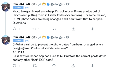
Here are the two tweets I posted to get suggestions for solutions. They didn’t get much engagement.

I put out a call on Twitter for suggestions but didn’t get any immediate responses. So I opened the App Store app and went hunting. What I needed was an app that would change the metadata for the file based on Exif date information.

Info Window Example
Here’s an example of a Mac OS Info window for an image file from my trip: a look at the Newark NY waterfront from a bridge. All of the information under More Info is taken from the JPEG Exif data. Note the dates; the Created date is today, when I dragged the file out of Photos to my desktop.

Exif, in case you don’t know, stands for Exchangeable image file format. According to Wikipedia, Exif

is a standard that specifies the formats for images, sound, and ancillary tags used by digital cameras (including smartphones), scanners and other systems handling image and sound files recorded by digital cameras.

Exif adds metadata tags to certain file formats, including JPEG, TIFF, and WAV files. These tags provide information about the media, including camera type and settings, media size, dates and times, and location (if available). Some of this information is available in the Info window for a file on Mac OS as shown here; I assume it can also be viewed in Windows.

The Exif data includes the exact date and time the photo was taken based on the clock inside the camera. (If the clock is wrong, that date and/or time will be wrong.) For some reason, dragging photos out of the Photos app into the Finder was copying the file but, in too many cases, using the current date and time as the image’s creation and modification dates. I needed to change that file info so it used the Exif photo creation time as the creation and modification dates in the Finder.

I found a few options that claimed to do what I needed to do. The one I found and decided to try first is called Bulk File Redate. It had a “lite” or trial version that enabled full functionality with just 10 files at a time. I think that’s an excellent way for a developer to give users a way to try their app before buying it.

It took me a minute or two to figure out the interface, but soon I was running batches of 10 images through it at a time. It worked like a charm. Great! I clicked the link to buy the full version, knowing I’d soon have hundreds of images to process. And that’s when I got a bit of a shock: it was $29.99.

Whoa.

Let me put that in perspective here. This app was a one-trick pony — an app that did just one thing: manipulate image date info. Yet it cost more than what I’d recently paid for Affinity Photo, a full-blown photo editing app? (Yes, I did get Affinity Photo at half price, but still!) I was not about to spend that much for it.

So I wrote to the developer. I didn’t want to be rude, but as far as I was concerned, he’d just lost a sale to me by asking (what I thought was) too much money for his little app. Surely he could make more sales with a more reasonable price. I wrote:

I just want to say that I was prepared to buy this app — I have about 500 pictures to work with — but I really think $29.99 is a crazy high price for this one-trick pony. If you reconsider your price, I’ll reconsider buying it. Otherwise, I’ll just do the photos 10 at a time. I like to support authors, but my pockets simply aren’t that deep these days.

That last line was a bit of an exaggeration. My pockets are deep enough, but I honestly didn’t think it was worth that much and didn’t want to be rude. And I do have a software budget. I simply can’t buy every single piece of software I might use just a few times a year.

I went on doing the photos 10 at a time. But because there was so much clicking involved — clearing the photo list after each run, adding more photos, dismissing dialogs, etc. — I soon tired of it. I didn’t have 500 photos to do. I had about 900.

So I went back online. I wound up buying Photo Mill: The Image Converter for $9.99. The reviews were good and it seemed to be able to do what I needed to do. I downloaded it, wondered for a while why two separate apps were downloaded onto my computer, launched one of them, and figured out the interface. It certainly had a lot more capabilities than Bulk File Redate. But it was also unable to do what I needed to do. Instead of using the Exif date to change the file created and modified dates, it allowed me to change the Exif date — which is exactly what I didn’t want to do. I went through the necessary steps on Apple’s website to get a refund and deleted the app(s). I wasn’t going to keep an app I couldn’t use.

Info for Photo
Here’s the same image file shown above after changing the dates with Photos Exif Editor. Note that the Created, Modified, and Last Opened dates are all correct now.

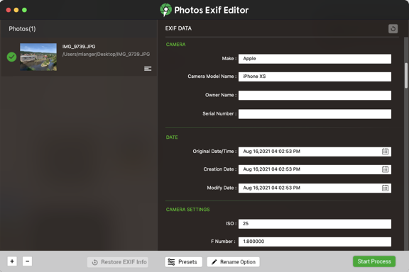
Back to the App store. I bought Photos Exif Editor for $4.99. Again, I deciphered the interface. I ran a few files through it. It wouldn’t overwrite an existing file but made a new file with (1) appended to the file name. To get it to work without changing the name of the file, I saved the files to a new folder and then just dragged them to the original folder and let Mac OS overwrite the originals. After playing around with it for a while, I got it to work the way I needed it to. I finished dragging the files over from Photos to the folder, did the date change, and was done.
Photos Exif Editor
Here’s some of the data for the photo in Photos Exif Editor before making any changes.

I then continued the process of archiving all those other media files until it was time for dinner.

Help from Twitter

In the meantime, I did get a response to my Tweet from Greg G, who follows me there (and has been known to comment on posts here — hi, Greg!). He advised me to use Photo’s Export command to copy the photos. I can swear I’ve tried that in the past with undesirable results.

So this morning I tried it again. And I noticed a command I hadn’t noticed before. (I don’t, after all, use Photos for very much other than collecting photos off my iPhone and iPad.)

Another Info Window
Check the dates for this exported image. They’re correct. I could have saved a bunch of time by just using this particular export command.

File > Export > Export Unmodified Original for X Photo(s) sure sounded like it would do what I needed to do. So I tried it.

And it worked.

I guess I could have saved myself a bunch of time and extra work if I just would have explored the options of the software I was already using. Duh.

Thanks, Greg! You sure made me wish I’d checked Twitter before all those trips to the App store.

Some Basic Economic Theory Applied to Pricing

This morning I got a friendly message from the developer of that first app, Bulk File Redate:

Glad to hear this app is desirable for you except its price.

The pricing-logic is easy:
A little bit amount of users work under big-batch-processing mode will pay it.

There is a promo code provided you to download it freely:XXXXXXXXXX
How to use promo code:
macOS App Store: Menu item Store -> View My Account -> Redeem Gift Card

May you enjoy it.

Not what I expected — or even wanted. I wanted to pay for the app. But I wanted to pay what I thought was a reasonable price: $10 or less. Heck, the app I wound up with, which does so much more, was only $4.99. I wanted the developer to be compensated for his work. I didn’t want a freebie handed out to me because I’d whined about the pricing. The unasked for promo code made me feel almost guilty. (What’s that all about?)

So I wrote back:

Thanks for the code, but I already bought another app. It was $4.99. I would have paid $9.99 for yours without batting an eye, and I think others would, too. Instead, I (and others?) went with a competing product.

I guess I’m just suggesting that you rethink your pricing strategy. Sometimes you can make a lot more money with a lower price.

Yeah, I guess was telling him how to run his business. But honestly — there’s always room in my Applications folder for a good one-trick pony and I’ll bet others feel the same way. But how many of them will spend $30 for one? For every 10 willing to do that, I bet there’s 50 willing to spend $10 or 100 willing to spend $5. So that’s $300 in revenue vs $500 in revenue. The app is already written so there’s no incremental cost. It’s simple economics.

And it’s not as if there aren’t other alternatives. There clearly are.

A response from him woke me up to his reality:

Thank you for your valuable suggestions first.

I had ever set the price on $9.99\19.99\29.99\39.99,
and I found the $29.99 was the best one that got me the maximum profits from selling.
I set the price at $29.99 eventually.

By the way,
I browsed ur website and your videos impressed me a lot,
such as Maria Fixes Her Toilet, Making Natural Wood Windowsills, Pole Building Construction, and lots of Helicopter Flying activities.

You are an amazing woman and I had followed you from Twitter.

Please feel free to reach me for helps.
Thank you very much.

(I might mention here (in case you haven’t figured it out) that English is not this guy’s first language. He’s Chinese. You can tell by his phraseology. Perfectly understandable, but a little weird for Americans.)

Well, apparently I’m a cheapskate. I replied:

Thanks very much. I’m sorry to have presumed that you didn’t experiment with pricing. That was very naive of me. Apparently, some folks have bigger software budgets than I do. I guess I’m just a cheapskate! Sorry!

I hope you’re doing well with your software development efforts. Good luck to you!

And for some reason, I don’t feel so bad about using the promo code he sent. We’ll see. I’d love to recommend Bulk File Redate — it really works flawlessly and is very quick. A perfect tool for processing hundreds or thousands of images. For me, I still don’t think it’s worth what he’s asking. I guess it depends on a person’s needs and budget. If you’re looking for an app to do this job, please do give it a try. The developer is a nice guy who does have a solid handle on how to run his business.

And I’m not just saying that because he might read this post. Or that he must have spent hours browsing this blog if he found my pole building construction posts.

The Archiving Continues

This morning, after breakfast, I’ll climb back up to the loft where my desktop computer and those little portable hard drives are waiting for me. I’ll finish up that archive and backup job. And then, maybe, I’ll do what I was really supposed to do yesterday: edit some new video for the FlyingMAir YouTube channel.

Snowbirding 2021: Drone Footage of Our Backwaters Camp

A look at our camp from the air.

I took out my Mavic Pro a few days ago and shot some footage of our winter camp.

I actually shot this on two different days. The first day, I took it up to get a few shots of my friend Janet, who was fishing from her boat down the backwater channel we’re camped on. I then shot a video overflight ending at our camp.

Watch My Helicopter Videos on YouTube

Time once again for a shameless plug…

Flying M Air Logo

If you like helicopters, you’ll love the FlyingMAir YouTube Channel. Check it out for everything from time-lapse annual inspections to cockpit POV autorotation practice to a flight home from a taco dinner at a friend’s house — and more.

I shot the second half the next day. I wanted to circle the camp from the air, but I wanted it set up as we usually have it. The first day, my truck was parked inside the living area because we’d offload groceries and water jugs. In the second half of the video, my truck is parked where it belongs, on the other side of the boat ramp.

The light was definitely better the first day I shot. I should have just moved the damn truck and kept shooting. My bad.

Anyway, here’s the video; I posted it on the FlyingMAir YouTube channel. Read the video description to learn more about my music choice.

Western Washington Wander 2020: Mt Rainier and the Buck Creek Campsite

I visit Mt. Rainier in near perfect conditions, then make camp in a weird campground on a weirder airstrip.

It was only about 10 miles from Union Falls Trailhead to Chinook Pass and we made the climb pretty quickly. And, for the first time ever, I stopped at the parking area right before the pass to check it out.

Smoky Valley To Chinook Pass
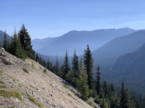
I also stopped along the road before getting to the pass. Here’s a look back down the valley (left) and ahead toward the pass (right).

At Chinook Pass

If you live on the east side of Washington State and do any business or pleasure travel to the Seattle area in the winter, your travel plans are ruled by the passes. North to South, the ones I know that may be open in winter are: Stevens, Blewett, Snoqualmie, Chinook, and White. There are likely other ones; heck, I’m not in Washington in the winter so I have no need to know them all.

From an elevation standard, none of them are very impressive if you’ve lived in high elevations. Chinook, for example, is only 6500 feet; for comparison, I used to own a cabin on some property in Arizona that was at 6700 feet.

From late autumn to early spring, weather and traffic reports always include pass conditions and closure information and no one who crosses the passes in winter travels without studded tires or chains. It’s odd because talk of the passes becomes as common as talk of the weather, even if you have no need to know what pass conditions are.

“That was some storm last night. They closed Snoqualmie and Blewett.”

“Yeah, but I think Stevens might still be open.”

Meanwhile, neither participant in the conversation has any need to cross any of the passes any time soon.

Chinook is the usual choice if you’re traveling from the Yakima area to the Tacoma area and aren’t in a huge hurry. The road that climbs through the pass — Route 410 — is one lane in each direction with the occasional passing lane thrown in to keep things moving uphill. It’s a scenic drive with the top half on the east side being through a relatively winding canyon and the top half on the west side offering stunning views of Mt. Rainier, conditions permitting. And that’s the thing about crossing any of the passes. It could be an awesome sunny day on the east (desert) side but when you cross the pass you could be in the middle of a rainstorm or fog bank. (It was freezing fog that I’d driven through on my west to east trip in October.) I can count the times on one hand that I actually saw Mt. Rainier from the pass. Thursday morning was one of those times.

But now I’m getting ahead of myself.

Chinook Pass Trailhead
This sign explained what trails were available to hike and reminded visitors that dogs were not allowed on most of them.

I parked in that parking area right before the pass, got the pups out, and walked to where there was a sign telling me what to expect. I should mention here that the lot was more than half full — as was the one across the road — but no one was around. It wasn’t the typical scenic view — looking down the way we’d come into a smoke-filled valley that day — pullout I always thought it was. It was a real trailhead for none other than the Pacific Crest Trail — the west coast’s version of the famed Appalachian Trail.

Of course, there were other shorter trails originating from the location and it’s a good thing there was. You see, no pets are allowed in Wilderness areas, which the Pacific Crest Trail winds through, and there were lots of No Pets signs to remind me. But a segment of the trail that started in the parking area did allow leashed dogs, so I set off with the girls to explore. The 1-1/4 mile hike we’d already had that morning wasn’t enough.

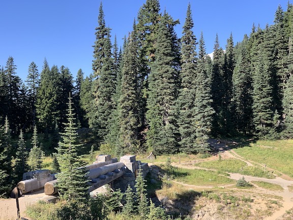
What I was hoping for was a glimpse over the pass down toward the lake right on the other side, which I’d originally planned to hike around that morning. I was also hoping to see Mt. Rainier. But this hike, although pleasant enough through wildflowers and forest areas, didn’t offer any views. Instead, the trail took me to the foot bridge that crosses over Route 410 at the summit of the pass. We walked over the bridge and up the trail a bit more — enough to see that it was a clear day on the other side and Mt. Rainier was visible. Eager to actually see the mountain, we turned around and headed back. The one trail branching off toward the lake was clearly marked with multiple No Pets signs so it looked like the only way I’d see it is by continuing the drive.

Bridge Over 410
A look back at the pedestrian bridge from the farthest we got on our little walk. That white thing beyond the trees on the right side of the photo is the top of Mt. Rainier.

We hadn’t even walked a mile.

The Photo Session

Back in the truck, we crossed under the footbridge I’d just walked over, rounded a bend, and wow! There was Mt. Rainier in its full glory, sagging glaciers shining in the sun against a blue sky. Right below the road was little roundish Tipsoo Lake, surrounded by green grass, flowers, and evergreen trees. I had just driven into a Bob Ross painting.

I pulled over in the topmost part of the strip of parking that lines the road there and got out to get serious about photography. That meant leaving the pups in the truck — windows cracked wide, of course — and going into the camper to fetch my Nikon. (No tripod; I seldom get that serious in bright light conditions.) I also grabbed my binoculars and strung their strap around my neck. Then I walked back up the hill, looking back now and then for the best view of the peak.

Now this is where casual photography and serious photography part. The vast majority of photography I do these days is casual. I whip out my cell phone, try to compose a decent shot using one of the optical zoom options (1x or 2x on my iPhone Xs these days), and snap. The best camera is the one you have with you. I believe that wholeheartedly. While the iPhone doesn’t have a great camera, it’s usually good enough.

But when I want to get serious about composition, I reach for my Nikon with its 28-70mm zoom (glass) lens. That gives me a huge amount of flexibility in composition, as well as full control over aperture and shutter speed. If you know a little about photography, you know that’s good. If you don’t, well stick to your point-and-shoot; it’ll do a fine job for you.

I’m willing to bet that 95% of the people who stand where I was parked point their camera at Mt. Rainier and push the shutter release. Done! Excellent shot of the mountain on a beautiful day.

But the real story wasn’t just the huge snow-capped mountain looming in the near distance. It was everything else around it: the trees, the lake, the flowers. The rocky peaks nearby. In my mind, the photo had to include some or all of those things. And that meant moving my ass (with my camera) to a better vantage point.

So I walked back up the side of the road, looking over my shoulder now and then to judge the view, and occasionally snapping a photo with my iPhone. Until I found the spot.

Mt Rainier through the Trees
One of the shots I snapped with my iPhone as I walked. I’m liking this one more and more as look at it.

In my opinion, photography starts with two things: light and composition.

I could not control the light. I was there on a sunny day at about 10:30 AM. No matter how you slice it, that’s not going to be “good light.” It’s going to be harsh, white light. Coming earlier — maybe around 7 or 8 AM — would have gotten me better light, but it likely would have put much of the scene in dark shadows. At least I had light on the whole scene.

I did, however, have some control over composition. The image I was imagining had something interesting or colorful in the foreground with the mountain out there in the background. Almost as if I were taking a photo of that foreground thing and this magnificent mountain just happened to be back there.

And that’s what I was thinking when I saw the bunch of yellow flowers — forgive me for not knowing what they are — swarming with bumblebees, with the mountain, trees, and lake beyond them. That’s where I parked my butt, on the gravely dirt alongside the road, whipped around my Nikon, and got to work.

Mt Rainier with Flowers
I don’t have the Nikon images available to share — I’m not in the practice of hooking up my camera to my laptop for blog posts — but this should give you an idea of what I was after. I’ll know if I succeeded when I open the Nikon images in Lightroom or even Preview to see what they look like.

I stayed for about 20 minutes — a time so short that a real photographer would laugh. But let’s face it: neither the light nor the scenery would change anytime soon. While I was there, I used my binoculars to study the glaciers on the mountain. There were lots of long cracks in the snowpack and I could imagine avalanches happening on a regular basis. I could just about see the blue of the glacial ice in some places.

I sat for a while longer just listening to the bees in the flowers in front of me. After a while I began spotting them. They were all bumblebees of a kind much smaller than I get around my butterfly bush back home. There were dozens of them, buzzing loudly as they flew around, gathering pollen for the winter.

Then I was ready to go. I returned to T2 to put my camera and binoculars away and got back into the truck where my pups were waiting patiently for me. I started up the engine and we continued on our way.

At Tipsoo Lake

I pulled into the main parking area for Tipsoo Lake, which was just down the road, still thinking about that hike around the lake with my pups. But I already suspected that would not be possible. The lake was within the Mount Rainier National Park and U.S. national parks are among the most dog-unfriendly places in the country. Stated simply by a ranger later in the day, you can’t take your dog off pavement. That means parking lots and campground roads only. No trails. No backcountry hikes.

This is a real turn-off for me and one of the reasons I visit national parks a lot less than I used to.

I sort of understand why they are so strict about dogs. It probably has a lot to do with people not cleaning up after their dogs. There’s not much less appealing than walking down a trail in the forest, enjoying the shade of tall trees and the sound of birds and then stepping into a pile of dog crap someone left on the trail. Or seeing someone’s bag of dog crap alongside the trail, as if putting it in a pink bag with a knot on top was as good as cleaning it up and taking it away. People are pigs and they ruin it for everyone else. I definitely have a blog post coming about that.

So after parking and rolling down the front windows of the truck halfway for my pups, I went to look for signs. Sure enough, there were No Pets signs all over the place. And honestly, the hike didn’t look pleasant enough to do by myself.

There were two Mennonite (or something similar) women by the signs studying the map. They wore typical floral print dresses that looked at odds with their hiking shoes. One of the women wore the little bonnet some of them do. They were trying to figure out how to get on one of the trails that wound around a nearby peak. It was a 3.4 mile loop. They were debating which way to go and eventually asked me. The map was pretty clear and I pointed out how I would go. They then left me, met up with a few more women in their group, and proceeded to walk the opposite direction. Huh?

I went back to the truck, started up, and continued driving down the hill.

At Sunrise

At the junction of Route 123, I got a surprise: a sign stating that Route 410 (the road I was on) was closed up ahead due to fire. I didn’t even know there was a fire on that side of the mountains.

My plan had been to camp out in the national forest near a place I thought might have chanterelle mushrooms. It was getting on to that season — although admittedly early and definitely dry — and a mushroom hunt was part of why I’d come that way. On seeing the sign, I had two questions:

  • Was the road really closed? I recalled the previous day when I’d ignored the sign and the road hadn’t been closed at all.
  • If the road was really closed, was it closed before or after the spot I’d hoped to camp?

As I did the previous day, I decided to ignore the sign and I kept going.

There was a plain old Road Closed sign at the turn for Sunrise, one of the park’s main access points. That looked pretty conclusive. I checked my watch. It was only around 11:00 AM. I made the turn into the park.

A while later, I was chatting with a ranger at the gate about the road closure (real and at Greenwater, after my mushroom hunting grounds), pet rules (see above), and what I could find at Sunrise (great views of the mountain).

There was a good chance I’d been there in the past; in the late 1980s, my future wasband and I had taken a road trip from Seattle to San Francisco and we’d visited both Rainier and St. Helens from the east side. Of course, I couldn’t remember details from that long ago. (Why do you think I blog? So I can remember details.)

I did know that if the road was closed ahead, fuel might be a concern. My truck’s computer said I had enough to go 184 miles, but my truck’s computer isn’t terribly reliable. I’ve gotten that thing down to 21 miles left on a long trip in the middle of nowhere and the related stress is something I’d prefer to avoid. I always try to fill up before it reaches 100 in remote areas. If I did the 19 miles (each way) to Sunrise and then went to my intended mushroom hunting spot would I have enough fuel to backtrack to Route 123 and Packwood, the nearest fuel? I did some math in my head, considered the number of times I’d passed the turn for Sunrise and not gone in, and thought about how early and dry it was for mushrooms. I headed up toward Sunrise.

It was a pleasant drive on a winding road that would have been a lot more pleasant behind the wheel of my little Honda S2000 than a fully loaded, top-heavy diesel truck. But I made the best of it. I passed a few places where I might have stopped for a little hike — if I were allowed to take my two best friends. There were few people on the road and I didn’t even have to pull over to let anyone pass on the climb back up to 6,400 feet. Soon I was pulling into a parking space in a huge, mostly empty parking lot, with the door of the camper pointing right out toward the mountain.

I took the girls out for a quick walk (on pavement, of course), then climbed into the camper with them for lunch. I reheated leftovers from the night before and sat in the doorway looking toward the mountain to eat them. Behind me, the girls climbed up onto the bed and worked on some chew bones they had there. From my seat, I could see a lot of ugly hand-scrawled signs on orange board that said No Pets anywhere you might logically want to take a dog for a pee. It was a real shame that they ruined the view that way.

No Pets View
Mt. Rainier out the back of my camper at lunchtime. Whose bright idea was it to scrawl PETS NOT ALLOWED on a big orange board in the view?

After lunch, I locked the pups up in the camper and walked over to the lodge. It was closed. A masked ranger sat at a table under a shade with a piece of Plexiglas in front of her. She had a map and info. I put my mask on, stepped up, and asked her questions. I made the mistake of reaching under the Plexiglas to tap something on the map with a fingernail.

“Don’t touch it!” she said.

Whoa.

I asked again if the road was really closed. She assured me that it was. She told me that the distance from Sunrise to fuel outside the park on a different road that went through the park was 64 miles. “All downhill?” I asked, knowing my truck gets way better mileage downhill than uphill.

She used the map to point out the downhill and uphill portions. It was a nearly even mix. I thanked her and left, noticing yet another Road Closure sign that assured me that the road would be closed for several days.

I went into the gift shop, bought an ice cream sandwich and a night sky reference guide, and went back to the camper. I had no desire to hike anywhere without my dogs. I took them for another pee walk, took another photo of the mountain, and headed out.

I stopped at Sunrise point on the way down the hill. It’s a small parking area nestled in the crook of a switchback. Some rangers were maintaining/repairing the cut stone wall that separated the parking area from the road. We chatted for a few minutes about the CCC, which built the infrastructure for most of the older national parks. (I later learned that this particular road project predated the CCC by a few years and was completed by private contractors for the government.) I checked out the view and an interpretive sign, then climbed back into my truck, where the girls were waiting, and continued down the hill.

Sunrise Point
Sunrise Point, looking back toward the mountain. You can see T2 parked among the cars there.

At the bottom, I consulted my truck’s computer. 149 miles until empty, it told me. The gauge said 1/4 tank. GaiaGPS, where I’d put the waypoint for my mushroom hunting grounds, told me it was 15 air miles away. It couldn’t calculate road miles without an Internet connection, which I hadn’t had for nearly 24 hours. It was only around 2 PM and I had no desire to search for a campsite in an unfamiliar area. So I made the left turn, passing the Road Closed sign, and headed toward Greenwater on Route 410.

There was also road construction along the road. I stopped at a flagger. She walked over and we chatted for a while as I waited for the pilot car. She’d just been stung by a bee. The only thing I had for her were some “antiseptic” wipes I’d bought to leave in the truck. I gave her a bunch of them. They were good and wet and I hoped they’d help take the sting out for her.

Then the pilot car came and I followed it past a road crew that was oiling and putting a layer of asphalt on the road. It was one lane for about 3 miles. As I drove, I eyed the forest on either side of me, sizing it up for the chance of finding chanterelles. It was the right kind of forest in many places. We passed out of the National Park and into the National Forest. By that point, I’d already decided to check out a closer camping area for an overnight stop and mushroom hunt: Buck Creek. I saw the sign and turned left.

Buck Creek Camp and Ranger Creek Airport

I’d never camped at Buck Creek, but I had attended two Puget Sound Mycological Society forays at the nearby Black Diamond Camp. That area was rich with mushrooms on the first year I went (when it was wet) and pretty much devoid of mushrooms on the second year I went (when it was bone dry). I figured I’d pull in to check out the camp.

Off 410, I crossed a bridge over the White River. The Skookum Flats Trailhead parking area was right on the other side of the bridge and I pulled in for a look. There was no one there. It might make a decent back up spot if Buck Creek didn’t work for me.

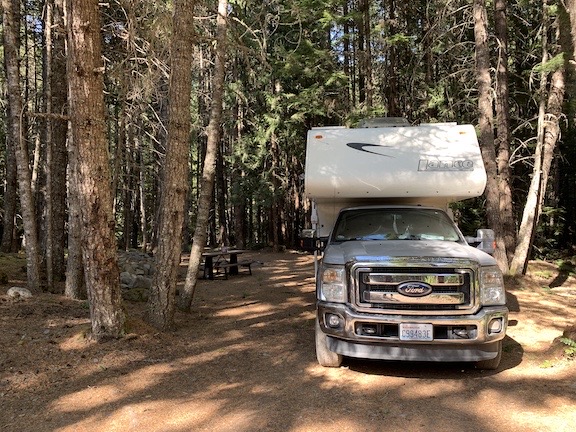
Back on the gravel road, I made the next left, following the signs for Buck Creek Camp. Although my Ultimate CG app had said camping was free there, a sign pointed down the road for a self-pay station. I continued down the road, passing a great campsite where I could back in on level ground under a canopy of evergreen trees with a picnic table. I continued on, wondering if it could get better than that. Unfortunately, the road was a mess and I soon got tired of bouncing along through potholes that must have resembled ponds after a rain. I turned around, went back to that first site, and backed in.

Buck Creek Campsite
Our campsite at Buck Creek was densely wooded and would have been very private even if we weren’t the only campers there.

We all got out and went for a walk in the forest behind the camper. It was exactly the kind of forest I’d expect to see chanterelle mushrooms, but ten minutes of looking everywhere came up empty. Too early? To dry? Both? We went back to the camper.

Buck Creek camp is right on the Ranger Creek Airport. In fact, one of the sites is right under the extended centerline for the runway. I was at the far end of that, beyond the runway end, but I could see the windsock and a building off in the distance. Although it was hot in the sun, I went with my pups toward that building, keeping in the shade as much as possible, looking for that self-pay station. The temperature varied with the amount of sun a spot got; where it was very warm it smelled like Christmas, if you know what I mean.

I soon realized a few things.

  • The campground was completely empty. We were the only ones there. I suspected that the road being closed had a lot to do with this. The only way to get to where we were from the Seattle area was to drive up around the south side of Mt. Rainier.
  • The campground appeared to have had buildings on site a long time before. I saw some concrete platforms and at least one stone foundation. Maybe this was a camp for workers when the park was being developed? I could not find any information about this online in a quick search.
  • The campground was not consistently maintained. Some sites had tables, others didn’t. I didn’t see any site numbers. I wasn’t even sure what areas were campsites and what areas weren’t.
  • The self-pay station was broken and unusable. There was no place secure to put money or even signs/envelopes to tell you what was due. (I guess it was free?)
  • The existing building was a pair of pit toilets with Men’s and Women’s sides. Neither door could be latched from the inside, which wasn’t a big deal since there was no one there. The toilets were surprisingly clean and even had some toilet paper.

Ranger Creek Airport
I was very surprised to see that the airport runway was paved.

By the time we reached the building, we were abeam the end of the runway, which I realized (with some surprise) was paved. The whole thing was surrounded by a low metal guardrail I have to assume was put in place to keep people from driving on it. (Too many people are idiots.) We crossed the runway and walked back on the other side, which was cooler with more shade and a few more campsites. I briefly considered moving my rig but decided that I liked it where we were, closer to the creek.

I spent the afternoon sitting at the picnic table with my laptop, working on the previous day’s blog post, adding photos as I worked. None of it could be posted yet, of course. I still had no Internet connection. I figured I’d upload what I’d finished the next day when I stopped at Packwood to refuel. The forest around me was very pleasant, although there were a few pesky flies for a while. I honestly don’t know much about evergreen trees, but these were the kind with the tiny needles and straight, tall trunks. All the way up were short, broken dead branches that had likely grown and thrived for a while before priority was given to the ones higher up. They swayed in the breeze, making occasional cracking sounds as the dead branches hit each other and sometimes broke off.

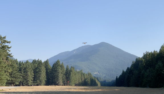
Sometime later in the day there was a bit of excitement when a plane flew low and I thought it was going to land. Then it moved away — into a downwind, I soon realized — and came in to land toward us. I took some video but it didn’t really come out very well because the plane was so far away. It stopped near the building, turned around, and back-taxied the way it had come from. At the far end of the runway, it turned around and took off again. It was a small yellow plane — that’s all I was able to see since it was already pretty high up by the time it reached us. I suspect it may have been a Cub.

Little Plane
Here’s that small plane departing from the runway.

I gave the girls new chew bones and they spent some time working on them. I noticed that Lily liked to sit atop a mound of rocks and dirt near the truck; I think she found that higher vantage point more secure. Once in a while, they’d wander off but return immediately when I called them. They were really shaping up to be good adventure dogs.

I had dinner outside on the picnic table: a piece of smoked salmon on a salad with some sliced up beets from my garden.

It got a bit too cool to sit outside not long before sunset and we all went inside. I continued working on my blog post. The girls went up to bed where they looked out the windows and occasionally barked at imagined monsters in the forest. I’ve become convinced that Rosie, who is more prone to bark, has poor eyesight and barks at shadows. Those shadows got longer and longer until they disappeared. I climbed up into bed and read for a while before dozing off.

The Other Campers

The first car’s headlights cut through the night around 8:30. I had just dozed off. The girls started barking and I was immediately awake to quiet them down. The car passed by the front of my site, heading toward the bathroom building we’d visited that afternoon.

I picked up my iPad to continue reading.

I was asleep again when the second car passed. More barking. More waking. More shushing.

The same thing happened three more times over the next two hours. By the last car, the girls didn’t even bark. I had no idea where the cars had gone — when I looked out into the darkness later on, I could see only darkness.

I finally fell back to sleep around 11 PM.

In the morning, after coffee and breakfast, I decided to take a walk back down to the bathroom building. Maybe we’d see where all those cars had gone.

We did. They were all parked in the campsites immediately across from the bathroom building. I kept the girls with me so as not to bother the other campers at 7:30 AM — only a few youngish guys were up and walking around. Another was in the bathroom marked Women; I could see him because (if you recall) the doors didn’t latch closed.

I managed to arrange a rock outside the door of the other toilet to give me some privacy. When the guy emerged from his toilet, the girls greeted him. I finished up quickly to keep them from being a nuisance. By that time, Rosie was getting petted by the guys by the cars while Lily was playing keep away.

They were from the Seattle area and, because of the road closure, had been forced to go the long way around to the campground. That had added two and a half hours to their drive, which is why they arrived so late. Of course, this just confirmed that the road was probably still closed and that I’d be on the same long drive soon enough.

I went back to camp and prepped for the day’s drive. I had to be in Maple Valley by noon to meet some old friends for lunch. I’d already decided that the route through Packwood, where I could definitely get fuel, was wiser that the possibly shorter (in distance but not time) route through the park. Because I had no Internet access, I had no way of knowing how long the distance was or how long the drive would take.

It was 8 AM sharp when we pulled out of camp.